Location: the walk begins in Cockermouth outside Wordsworth House and provides the opportunity for splendid views of Cockermouth, the Lorton Valley, Skiddaw and across the Solway Firth
Distance: 8 miles.
Map: OS Outdoor Leisure 4: The English Lakes North Western area.
Terrain: largely on public footpaths across fields with some sections on minor roads. With some gradual climbs
Church: St Michael, Isel (NY162333)
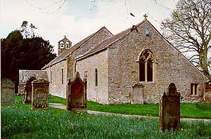
Set in its quiet churchyard backed by trees, overlooking green fields and close to the River Derwent, there is an overall feeling of tranquillity here. Sir John Betjeman (Guide to English Parish Churches) ranked Isel as, “a perfect English harmony of man and nature”.
It is probable that there was an earlier church on the site but the present building dates from about 1130. It retains its Norman appearance - a small low structure with narrow windows and a lower chancel roof. A defensive tower, common for border churches, was built onto the west end. The date of its construction is not known but it was in existence in 1710 and was demolished sometime thereafter being replaced by the small bellcote. An extensive restoration programme in 1878 was essentially just that - i.e. restoration with little additional Victorian embellishment apart from the west window.
Among the features of interest are:
|
|
The Walk
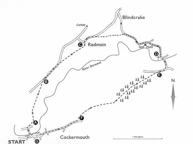
Start at the west end of Cockermouth’s Main Street outside Wordsworth House, birthplace of the poet William Wordsworth. With the house behind you, go left and then turn first left down Bridge St. Go over the footbridge and keep straight ahead to pass the former Derwent Mill, now converted into apartments. Go over the road junction and follow the pavement as it bears right. Cross over the road to follow a public footpath sign before the Cumbria County Council buildings and follow the path with a wall/hedge on your left to a stone stile (A).
Cross the stile and bear slightly left as you climb the steep grassy bank ahead. Continue ahead to go through a metal kissing gate and the small metal gate behind. Walk straight ahead over the pasture land climbing gradually more or less parallel to the telegraph wires on your left. Cross the large stone stile in the right hand corner of the hedge and bear right with a hedge/wire fence on your right to cross another large stone stile. Proceed in the same direction to cross a further stone stile.
The path levels off as you continue ahead with the wire fence on your right and then drops down to a driveway (to Wood Hall). Cross the driveway in the direction of the public footpath sign. The path is rather vague as you climb to the left of the hawthorn bushes and pass a clump of trees to reach a waymarked stile at the corner of a plantation.Cross the stile and proceed in the direction of the waymark along the top of the ridge to a stone stile. Cross the stile to exit onto the A595 Cockermouth-Carlisle road (B).
Turn right and walk along the wide grass verge for some 700 metres to a lay-by. Go over the stile next to the gate and take the public footpath “Redmain”. Bear diagonally left across the corner of the field to take a double stile.
Continue straight ahead across the field and make for the left-hand side of the plantation ahead. Then continue with the edge of the wood on your right to cross a stile. Continue in the same direction along the side of the wood and after some 300 metres cross another stile at the corner of the wood. Walk towards the rocky outcrop ahead, behind in the distance is Binsey the Lake District’s most northerly fell. Just before the rocky outcrop a clear green track goes off to the left, follow it as it descends to join another track and continue straight ahead and soon pass through a gate. Follow the metalled road past the farm buildings and climb a short distance to join a minor road (C).
Turn right and follow the road through Redmain. Leave the road just beyond the entry sign to the village to take the public footpath “Blindcrake to Isel Road ½ mile”. Cross the stile and bear right to pick up a path just before the top of the rise. Cross the stile and go through the stone gap and continue ahead bearing slightly right towards a gap in the hedge. Take the waymarked stile to the left of the gap. Proceed straight ahead down the field to a waymarked stile at the edge of the woods. Follow the path ,which can be muddy in parts, through the woods crossing the beck via a footbridge. At a crossing of paths follow the finger post towards the Isel Road.
At the road, turn right and proceed ahead for about a mile. You pass Isel Hall (an Elizabethan Grange and fortified pele tower, open to visitors on Mondays 2-4pm, April-October). At a road junction take the right fork (Bassenthwaite & Cockermouth) to arrive, after about a mile, at St Michael’s Church and its former vicarage (D).
After visiting the church, walk back up the church drive to the road and turn right. Follow the road as it bears right to cross the bridge over the River Derwent. The road now climbs quite steeply to a T-junction. Turn right, continue for about 250 metres and as the road bears right, leave it to take the public bridleway on the left now part of the Allerdale Ramble and the Reivers Off Road route (E).
Follow the clear track until, after ascending through the trees for some time, you come to a fork in the track. Take the right fork and climb steeply through the edge of the wood with a stone wall over to your right. As the track turns sharply to the left, bear right to leave the wood via a stile next to a gate. Continue ahead on the grassy track with a wall on your right. Soon after passing the corner of the wall and ignoring a waymarked gate, you begin to get splendid views of Cockermouth below with the spire of All Saints Church (1852) where Wordsworth’s father is buried. Continue downhill with the wall on your right via several gates/stiles until the path eventually bears left to exit onto a road (F).
Turn right and follow the paved path, adjacent to the road, passing Cockermouth High School. A few hundred metres after the school you cross Isel Road and about 100 metres further on you pass the remains of the 14th century Cockermouth Castle (now a private residence with largely Victorian additions). Just beyond the castle, turn right at the Quince and Medlar (an award-winning vegetarian restaurant) and descend to pass Jennings’ Brewery (1828). Continue ahead to cross a bridge over the River Cocker just prior to its confluence with the River Derwent (G).
Turn right and go along Waterloo Street for a few hundred metres and turn right opposite River View to follow the sign “To the river”. Go along the riverside path and a few metres after passing beneath a footbridge you pass the walled garden of Wordsworth House. The path turns left into a side road that soon leads back to Main Street, Wordsworth House and the end of the walk.

Adapted from Walk 6 'Isel and Bridekirk', from 'Lakeland Church Walks' by Peter Donaghy and John Laidler, published by Sigma Press 2001.

